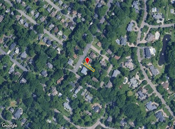
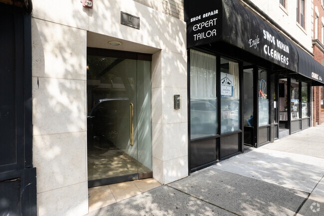
Property Record
12 Engle St, Cresskill, NJ 07626


Current Lease Availabilities
NEARBY LISTINGS FOR SALE OR LEASE
Property Detail
12 Engle St
New York-Jersey City-White Plains, NY-NJ
Alpine Crest Sec 1
08-00092-02-00016
Bergen
Sfr
New Jersey
X
0.14 AC
34003C0212H
GW Bridge
2,171 SF
Northern New Jersey
DEMOGRAPHICS near 12 Engle St
1 Mile
3 Mile
5 Mile
2024 Total Population
19,982
158,605
1,112,535
2029 Population
19,983
158,316
1,066,789
Pop Growth 2024-2029
+ 0.01%
(0.18%)
(4.11%)
Average Age
40
42
40
2024 Total Households
7,205
57,670
409,675
HH Growth 2024-2029
+ 0.06%
(0.16%)
(4.36%)
Median Household Inc
$77,089
$110,430
$60,473
Avg Household Size
2.60
2.60
2.60
2024 Avg HH Vehicles
2.00
2.00
1.00
Median Home Value
$437,693
$490,138
$480,564
Median Year Built
1955
1957
1950
Nearby Places
- Restaurants
- Banks
- Shops
- Fitness
- Groceries
PUBLIC TRANSPORTATION
AIRPORT
LaGuardia
DRIVE
WALK
Distance
LaGuardia
33 min
18.5 mi
Newark Liberty International
DRIVE
WALK
Distance
Newark Liberty International
29 min
22.8 mi
Westchester County
DRIVE
WALK
Distance
Westchester County
43 min
29.2 mi
Freight Ports
NY - Red Hook Container Terminal
DRIVE
WALK
Distance
NY - Red Hook Container Terminal
43 min
25.1 mi
Nearby Properties
Address
Land Use
TOTAL SIZE
Lot Size
Zoning
Address
Land Use
TOTAL SIZE
Lot Size
Zoning
111.37 AC
P1
Address
Land Use
TOTAL SIZE
Lot Size
Zoning
289.02 AC
P
Address
Land Use
TOTAL SIZE
Lot Size
Zoning
572,137 SF
14.11 AC
R-D
Address
Land Use
TOTAL SIZE
Lot Size
Zoning
185.35 AC
P
Address
Land Use
TOTAL SIZE
Lot Size
Zoning
219.71 AC
O
Address
Land Use
TOTAL SIZE
Lot Size
Zoning
166.61 AC
P
Address
Land Use
TOTAL SIZE
Lot Size
Zoning
100,151 SF
22.13 AC
B2
Address
Land Use
TOTAL SIZE
Lot Size
Zoning
4,000 SF
14.69 AC
Address
Land Use
TOTAL SIZE
Lot Size
Zoning
5.22 AC
APT
Address
Land Use
TOTAL SIZE
Lot Size
Zoning
185,878 SF
33.44 AC
B
Address
Land Use
TOTAL SIZE
Lot Size
Zoning
135.51 AC
RR
Address
Land Use
TOTAL SIZE
Lot Size
Zoning
94.42 AC
P
Address
Land Use
TOTAL SIZE
Lot Size
Zoning
Address
Land Use
TOTAL SIZE
Lot Size
Zoning
225.36 AC
O
Address
Land Use
TOTAL SIZE
Lot Size
Zoning
450,784 SF
42.36 AC
R4
Address
Land Use
TOTAL SIZE
Lot Size
Zoning
9.48 AC
RA
Address
Land Use
TOTAL SIZE
Lot Size
Zoning
Address
Land Use
TOTAL SIZE
Lot Size
Zoning
1.12 AC
Address
Land Use
TOTAL SIZE
Lot Size
Zoning
68,824 SF
34.75 AC
R-D
Address
Land Use
TOTAL SIZE
Lot Size
Zoning
7.34 AC
Address
Land Use
TOTAL SIZE
Lot Size
Zoning
28.78 AC
B2
Address
Land Use
TOTAL SIZE
Lot Size
Zoning
163.19 AC
Address
Land Use
TOTAL SIZE
Lot Size
Zoning
173,890 SF
23.80 AC
O
Address
Land Use
TOTAL SIZE
Lot Size
Zoning
21,250 SF
2.37 AC
SBD
Address
Land Use
TOTAL SIZE
Lot Size
Zoning
36.90 AC
MU
Address
Land Use
TOTAL SIZE
Lot Size
Zoning
Address
Land Use
TOTAL SIZE
Lot Size
Zoning
Address
Land Use
TOTAL SIZE
Lot Size
Zoning
478 SF
10.45 AC
Address
Land Use
TOTAL SIZE
Lot Size
Zoning
Address
Land Use
TOTAL SIZE
Lot Size
Zoning
202,062 SF
29 AC
O
The World's #1 Commercial Real Estate Marketplace
Connect with us
© 2025 CoStar Group
The information above has been obtained from sources believed reliable. While we do not doubt its accuracy we have not verified it and make no guarantee, warranty or representation about it. It is your responsibility to independently confirm its accuracy and completeness. Any projections, opinions, assumptions, or estimates used are for example only and do not represent the current or future performance of the property. The value of this transaction to you depends on tax and other factors which should be evaluated by your tax, financial, and legal advisors. You and your advisors should conduct a careful, independent investigation of the property to determine to your satisfaction the suitability of the property for your needs.